

33-02. (H) IFR Navigation plan
Всего заданий: 13
В режиме ОБУЧЕНИЕ показываются все задания дисциплины с предъявлением правильных ответов. Для перехода к следующему заданию нажать кнопку «Далее».
Заданий на экзамен: 10
В режиме ЭКЗАМЕН правильные ответы не показываются, переход на следующее задание происходит автоматически, после выбора ответа.
1. On an instrument approach chart, a minimum sector altitude (MSA) is defined in relation to a radio navigation facility. Without any particular specification on distance, this altitude is valid to:
2. An IFR flight is planned outside airways on a course of 235° magnetic. The minimum safe altitude is 7.800 ft. Knowing the QNH is 995 hPa, the minimum flight level you must fly is:
3. An airway is marked FL80 1500 a. This indicates that:
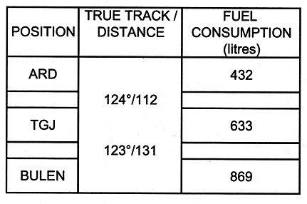
4. (Refer to figure 033-64) True Air speed: 170 kts Wind in the area: 270° / 40 kts According to the attached the navigation log, an aircraft performs a turn overhead BULEN to reroute to ARD via TGJ. The given wind conditions remaining constant. The fuel consumption during the turn is 20 litres. The total fuel consumption at position overhead ARD will be:
.
5. Which approach segment starts at the FAF and ends at the MAPt?

