

33-02. IFR Navigation plan
All questions: 33
In mode TRAINING show all questions of the discipline with correct answers presentation. To go to the next question, click the “Next”.
Questions for exams: 30
In mode Exam correct answers are not shown, after choosing the answer, transition to the next question occurs automatically.
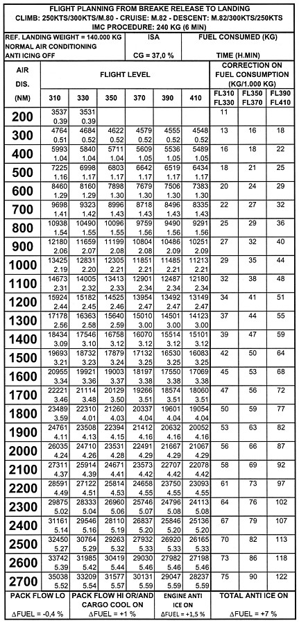
1. (Refer to figures 033-24) Assuming the following data: Ground distance to be covered: 2.000 NM Cruise flight level: FL330 Cruising speed: Mach 0,82 (TAS: 470 kts) Headwind component: 30 kts Planned destination Landing Mass: 160.000 kg Temperature: ISA, CG: 37% Total anti-ice: ON, Pack flow: HI Time needed to carry out such flight is:
.
2. An airway is marked 5000 2900a. The notation 5000 is the:
3. (Refer to figures 033-30, 033-31 and 033-18) You have to cover an air distance of 2.000 NM. What will be your flight time given the following information?
Takeoff Mass: 150.000 kg
Planned cruise: FL350
Long range MACH Standard Atmosphere (ISA)
CG: 37%
.
4. On a given path, it is possible to chose between four flight levels (FL), each associated with a mandatory flight Mach number (M). The flight conditions, static air temperature (SAT) and headwind component (HWC) are given below: FL370 M 0,80 Ts: -60 °С HWC: -15 kts FL330 M 0,78 Ts: -60 °С HWC: – 5 kts FL290 M 0,80 Ts: -55 °С HWC: -15 kts FL270 M 0,76 Ts: -43 °С HWC: 0 The flight level allowing the highest ground speed is:
.
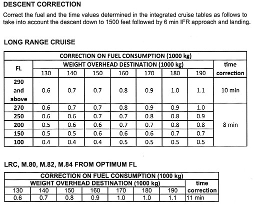
5. (Refer to figure 033-17) A turbojet aeroplane is flying using the following data: Flight level FL250, Long Range (LR) cruise, mass of 150.000 kg Temperature: ISA Headwind component: 100 kts Remaining flight time: 1 hrs 40 min The ground distance that can be covered during the cruise flight is:
.
