

33-02. IFR Navigation plan
Всего заданий: 20
В режиме ОБУЧЕНИЕ показываются все задания дисциплины с предъявлением правильных ответов. Для перехода к следующему заданию нажать кнопку «Далее».
Заданий на экзамен: 20
В режиме ЭКЗАМЕН правильные ответы не показываются, переход на следующее задание происходит автоматически, после выбора ответа.
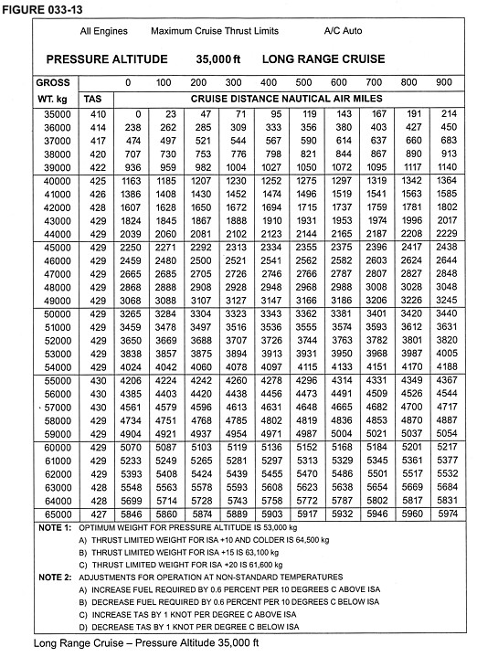
1. (Refer to figure 033-13) Find the TAS and the distance covered (NGM) at the end of the following flight segment. Given: Cruise: LRC at FL350 Temperature: -45 °С Wind: 40 kts head Start mass: 60.000 kg End mass: 55.000 kg
.
2. (Refer to figure 033-47) What is the time to alternate? Given: Distance to Alternate: 400 NM Landing Mass at Alternate: 50.000 kg Tailwind component: 50 kts
.

3. (Refer to figure 033-14) Find the climb time for en-route climb 280/0,74. Given: Estimated Takeoff Mass: 57.500 kg Initial cruise: FL280 Average temperature during climb: ISA -10 °С Average headwind component: 18 kts
.

4. An airway is marked 5000 2900a. The notation 5000 is the:
5. On an instrument approach chart, a minimum sector altitude (MSA) is defined in relation to a radio navigation facility. Without any particular specification on distance, this altitude is valid to:

